.

.
DAYS 25-28 ......................................................................................................................................................... FROM LEES FERRY TO NEARLY TO CEDAR RIDGE
Showing posts with label Big Rock Candy Mountain. Show all posts

Friday, June 10, 2016

Big Rock Candy Mountain - Marysvale (Day 11)


September 12, 1884 - Richfield to Elsinore (nooned) to Marysvale
Day 11 of 44 - (Week 2)
Richfield to Elsinore = 31 Miles* (Total Miles = 239)*
Total Trip Average Miles Per Day = 21.7; Average Miles Per Day - Week 2 = 23.6
*mileage for this day not included in journal - calculated by google maps


September 11 - 12, 1884
September 12 - 13, 1884


Original Journal Entry
"12 Sep. Arose early John Hunter's teams gone hunted till 10 o'clock found them and Started, went little south of Elsinor and nooned - very windy - hitched up and drove over the mountain in the dark arrived at Marysville about 10 o'Clock Pastured our teams for 12 1/2 per span." 

Final Journal Entry
"Sept. 12 arose early, John C. Hunter's team gone, hunted until 10 o'clock, found them and started, nooned south of Elsenore, very windy - drove over the mountain in the dark to Marysville, arrived 10 o'clock.  Paid 12 1/2 per span pasture."

Note on Journal Entry: This was the second most mileage covered in one day and they went over a mountain.  This most miles covered was their second day out from Slagtown to Fairfield - 35 miles over  a fairly level traveling area.   This was also the least they had paid per span for pasture.  A long day and they didn't get started until 10:00 A.M. 

They got a late start because John C. Hunter's team was gone.  This is the first mention of John C. Hunter.  Who was he?  John Coutts Hunter was born in Scotland in 1848.  He made the trip when he was 35 with his wife Elizabeth (24) and their two children, James (2), and Elizabeth (1).  They were from West Weber, Utah.


John Coutts Hunter
John C. Hunter was mentioned three other times in the C. P. Anderson Journal:

October 23, 1884:   
John Hunter  drew for land with 11 others shortly after he arrived in St. Johns.
June 6, 1885:         
The Anderson family went to the sawmill. Over Sunday they stayed with John Hunter and his wife.                                                
July 6, 1885:               
John C Hunter and David E. Garner returned to Utah.  They were neighbors   to the Andersons in St. Johns.

David Garner was from Ogden, Utah His life sketch gives an interesting account (click)   of his trip to St. Johns.  It was a very difficult journey for the family.


Elsinore

Elsinore (click) was originally called Little Denmark because many of the early settlers were immigrants of that country.  At one time it was home to a Utah-Idaho Sugar Company factory.
Nooned South of Elsenor

Big Rock Candy Mountain

After Elsinore and about 5 miles before you reach Marysvale (click) you see Big Rock Candy Mountain.  A fun and scenic place to stop today.  In 1884 the Andersons were crossing the mountain late on what had been a windy day.  It was getting dark and even if they could still see the mountain they weren't thinking "candy mountain."

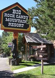
Big Rock Candy Mountain

Near the soda water fountain
At the lemonade springs
Where the bluebird sings
On the big rock candy mountain."


The song "Big Rock Candy Mountain" was made famous in the 1950s by Burl Ives.  The lyrics describe a traveling hobo who comes down the tracks to find the peace and perfection of the Big Rock Candy Mountain.

The colors come from many millions of years of mineralization caused by a complex chemical process involving hydrogen sulfide steam, ground water, and oxygen.  Ancient volcanoes erupted leaving colorful mineral deposits.  There are shades of yellow, red, orange, and even white volcanic rock.  It is a caramel colored group of hills.  The spring trickling down the yellow rocks looks just like lemonade mentioned in the lyrics.


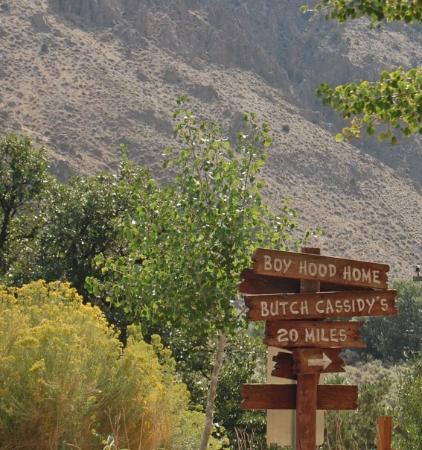
Butch Cassidy's boyhood home will be seen down the road about 20 miles.
photo is courtesy of TripAdvisor

 "Big Rock Candy Mountain"


A little Piute County History (Click including Butch Cassidy. Marysvale is in Piute County

Marysvale


Arrived in Marysvale at 10:00 P.M.
Marysvale - stop and smell the roses hollyhocks
Marysvale-or stop and smell the hot dogs
sign in Marysvale


possibly camped near the river in Marysvale


 For the first time C. P. Anderson did not include the miles traveled in this journal.  Perhaps it was such a long day he forgot.  We'll certainly give him the benefit of the doubt.  It was not difficult to find the miles traveled  using Google Maps.  It took them 12 hours to cover the territory on this day, plus the time to find  the lost horses.  Today it is an easy 39 minute drive to travel the 31 miles according to the map.


Today we learned about a fictitious hobo from Big Rock Candy Mountain.  Tomorrow we will have the privilege to meet a very real person in what is called Junction today.  
SaveSave

Friday, June 3, 2016

Coca Cola - Richfield (Day 10)


September 11, 1884 - Salina to "Cedar Ridge" (nooned) to Richfield

Day 10 of 44 - (Week 2)Salina to Richfield = 20 Miles (Trip Total = 208 Miles)

Total Trip Average Miles Per Day = 20.8;  Average Miles Per Day - Week 2 = 21.8


September 11 - 12, 1884
September 10 - 11, 1884


My mind wandered when I reached this point in the journal.  I couldn't find a town of "Cedar Ridge" because I'm not sure there was one, but the Cedar Ridge Station was probably close to it.  Maybe it was just a "cedar ridge." The writing on the door to me was a connection to the coke dispenser in St. Johns.  Was this where the idea came from?  Never mind that Coca Cola wasn't invented until 1886, two years later, or this sign wasn't painted on the door until much later.  Both the Cedar Ridge Station and St. Johns Drug Store knew what brought people through the door.

I love reading the posts in "You Know You're From St. Johns," and hope you will bear with me in sharing my blog post for today with this Facebook page from my hometown.


After many of your ancestors reached Kanab and followed The "Honeymoon Trail," they went through the "same doors." At that point there was only one way to go and they followed the water trail. That trail led to Johnson Canyon, Navajo Wells, House Rock Spring, Jacob's Well, Soap Creek, Badger Creek, Lee's Ferry, Navajo Spring, Bitter Springs, Willow Springs, Moenkopi, Black Falls, Grand Falls, and Sunset where they crossed the Little Colorado to settle in St. Johns and many other communities in Arizona.  You are invited to come along with me.  Make sure you bring  plenty of Coca Cola for the journey.

For those who haven't followed this blog, the original journal entry is posted first.  My great grandfather then revised that journal entry to another journal from which was typed the journal which is ONLINE (CLICK).  That is where the final journal entry post come from.

Original Journal Entry
"11 sep.  We traveled to cedar little South of "Cedar Ridge" and nooned - then we drove to Richfield arrived there long before sundown Bought some grain and camped the whole country is red it is very dusty traveled 20 miles."

Final Journal Entry
"Sept. 11 we traveled little passed Cedar Ridge - nooned - then drove to Richfield - traveled 20 miles. Bought grain.  Country very red."

Vermillion Cliffs near "Cedar Ridge"

The name "Cedar Ridge" may have come from
 the cedars on this nearby ridge
This is the town the "Cedar Ridge" Station
is in today

"Cedar Ridge" Station and Sign on the Door
Cedar Ridge Station
The station is closed.  No Coca-Cola today. 


l


The "Red-Headed Lady"
read below to see the origin of this name

A conversation from Facebook about the Coca-Cola Dispenser


Memories from Carl Carter of the Drug Store and Coca-Cola


"I have great memories of the old St. Johns Drug Company when it was downtown.  Grandpa owned it and then Al Anderson bought it.  I worked there as a teen as did others.  They had the most productive coke machine in the great State of Arizona!  After I married and took my wife there--she could not believe that the most expensive item on the menu was just $0.60 a banana split.  Sodas were a quarter and you could get a cherry phosphate or a cherry lime-aid for less than that.  It was a social hub to be sure.  I am sure that there were a lot of babies nursed by mothers who got their Coca-Cola at "The Drug".  From working there, I learned a lot of good things.  The most important was that if you opened up at 8:00 am, you needed to be there early to get ready for customers at 7:50 am.  They lined up early to get the first and freshest Coca-Cola!  Joy B. Patterson was always the first one there on a Saturday morning."

Added June 2, 2016 by Carl Carter

"The Drug had that red Coke machine that took syrup right out of the gallon jar and produced a euphoric elixir that could not be duplicated.  When you ordered a Coke, you got the real deal! And banana splits were only $.40! Lots of love went into that fountain.  I worked there during high school and loved it!  My job early in the mornings was to scrub off the front walkway-and that meant deep down scrubbing with a brush.  That was the welcome mat to all of the Coke-a-holics that passed through the glass door, past the scale that weighed and told your fortune for only a penny and belly up to the fountain to get your fix.  People set their watch by it.  Babies in town spurned mothers' milk and much preferred that Coke.  Legendary!"

From "Cedar Ridge" the journey continued to Richfield
for Day 10 on the journey to St. Johns, Arizona in 1884

After nooning it was about 9 miles to Richfield
The family camped in Richfield


A fun place to visit while you're "camping" in Richfield
A very short hike is required.  For more information click here.
Topographical map from Salina to Richfield


The Battle of Cedar Ridge (see history May 29, 2014 - 2nd entry-scroll down) was likely fought in this area somewhere. ("When at Cedar Ridge at Rocky Ford now within in
 limits of Vermillion.")


Map from Salina to Richfield  


The journal says it was 20 miles from the Sevier River to Richfield.  If you go from the Sevier River to the Walmart Supercenter in Richfield, it is 19.9 miles and right on if we round it to 20 miles.  It would be great if Google Maps could always match up with the Journal that closely.


Join the next blog at Big Rock Candy Mountain where the sun shines everyday and then on to Marysvale!


The lyrics here are for children.  They are different here than they were originally.   The pioneers certainly didn't think of this as a candy mountain. It was just another mountain to cross. Today we can have fun with it.


 Please excuse some of the formatting errors.  What shows up on my screen does not always appear in the same format on the final copy.


SaveSaveSaveSaveSaveSaveSaveSaveSaveSaveSaveSaveSaveSaveSaveSaveSaveSaveSaveSaveSaveSaveSaveSaveSaveSaveSaveSaveSaveSaveSaveSaveSaveSaveSaveSaveSaveSaveSaveSaveSaveSaveSaveSaveSaveSaveSaveSaveSaveSaveSaveSaveSaveSaveSaveSave
SaveSave