This is a different heading than you are used to. I want you to know I have fun on this journey especially researching, but also writing and mapping it out.
I had to take a moment to celebrate today. On the 25th, 27th, and 28th (the 26th they didn't travel), the Anderson Family traveled 10 miles. But the reason the "judges" gave me three perfect 10's was because the maps agreed with this as well. What are the odds of that happening? So the 10's aren't just the best you can get in sports. They actually represent 10 miles traveled and agreement with the maps as well. Again, what are the odds?
Three perfect 10's for three days when they traveled 10 miles and the maps agreed that it was 10 miles. Three "Judges" gave me a 10. You have to stop sometimes and enjoy the journey. Enough said. On with the post. I made it to Navajo Springs and more importantly finally found the inscriptions!
September 28, 1884 - Navajo Springs to Bitter Springs
Day 27 of 44 - Week 5 (Day 1)
Navajo Spring to 5 miles (nooned) to (south of) Bitter Springs = 10 miles: Total Miles = 459
Total Trip Average Miles per Day = 17: Average Miles per Day - Week 4 = 10

 |
| September 28 |
Original Journal Entry
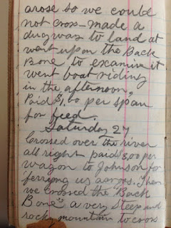
Sunday 28
Arose early John Hunters and Phillip De La Mare's Horses were by camp, but mine were gone, I followed there tracks - found them about 4 miles from camp by the edge of the Big Colorado on good feed - the banks of the Colorado are estimated to be 1500 feet high where I found the horses. Hitched up and drove about 5 miles turned out on good feed then we drove to Bitter Springs and watered our horses and went a little ways south of Bitter Springs and camped on good feed went about 10 miles in the after noon road sandy in places.
This was the longest journal entry so far.
Final Journal Entry
Sunday Sept. 28. My mules was gone, others present - I followed their tracks, found them 4 miles from camp on the banks of the Big Colorado River on good feed. The banks of the river is 1500 feet at this place. Hitched up and drove 5 miles, turned out on good feed - then we drove to Bitter Springs - watered and went on two miles - 10 miles in afternoon, some sand.
He shortened his final journal entry. He left out of the final journal entry what I felt was the most important part (Sorry Grandpa) - John Hunter. John Hunter was first mentioned on DAY 11 of the Journal. Possibly he had gone ahead and they had caught up with him, or he just wasn't mentioned again until now.
Anna Anderson provides us a little more detail. Se said in her life sketch: "It wasn't long until we caught up with several families enroute to St. Johns, Az. This made the rest of the journey more pleasant. Possibly John Hunter was one of the people they caught up with. The Journal is silent as to who the other people were, Whether the horses had feed and water was more pertinent to Charles Anderson.
Navajo Springs Inscriptions
I said in my last post I would cover Navajo Springs in this post instead of the day they arrived there as I usually do. This was a major stopping place along the trail. Enough time was spent at this watering hole for many pioneers to inscribe their names on the rocks. There are about eighty inscriptions found here.
Each of these inscription represented a person and a story could be told. Below are a few examples of the stories behind the names.
Peter Niels Skousen was attending the school of Deseret when his father James was called to help settle Arizona. He left school to help his mother run their farm in Draper, Utah. In 1877, his father returned for him, his brother Willard, and their mother Sidsel. They arrived at St. Joseph the day before Christmas of 1877. Peter was a single man of 20 when he stopped to inscribe his name in 1877 at Navajo Springs. He married in 1883. More can be found about him by clicking here

Little is known about Herman Snow who inscribed his name upside down on the rock below in 1881. He may have been the son of Bernard Snow. If this was him, he was single and about 20 years old at this time. Perhaps he went along to drive one of the wagons. He was married the next year. Fact without sources is mythology though and until there is more information, his claim to fame is he inscribed his name upside down at Navajo Springs in 1881. More information about his possible family can be found here. (familysearch)


On August 6, 1884, Nehemiah Wood Birdno (Beirdneau) and his 10 year old son Enoch Lewis Birdno (difficult to read) (Beirdneau) inscribed their names at Navajo Springs. Nehemiah was a blacksmith by trade and was the foreman for tempering and sharpening the tools that were used for cutting the blue lime rock used in building the logan Temple. He was called on a mission to Saint Johns, Arizona. He and his wife Mary and family left Logan June 4, 1884. They travelled the main road through Brigham City, Salt Lake, Provo and Panguich, and then to Little's Ranch. There they learned the Big Colorado was so high it was impossible to ferry across so they remained at Little's Ranch until July. Upon reaching the river, they found it still so swollen the operators of the Ferry wouldn't attempt to take the ferry across. Finally it was decided to swim the cattle and by tying two boats together, the wagon could be loaded on them. After taking the boats and wagons up stream about a half mile, they started across, but a hard wind struck the cover of the wagon and turned the boats back to the shore they had started from. They then took the boats and wagons back up stream about three-quarters of a mile. This time they removed the covers from the wagons and made it all right. The Andersons might have seen this inscription when they arrived at Navajo Springs the next month.
By the time the Birdno family reached Joseph City the services of a blacksmith had already been acquired. A blacksmith was needed in the Gila Valley so they journeyed on and arrived in Pima, 29 November, 1884. (see end of history).
Nehemiah's grave can be found here and life story here (My Heritage Website). He was a personal bodyguard of the Prophet Joseph Smith.

On of the clearest inscriptions is that of G W Davis who inscribed his name August 17, 1884, but his history is not so clear. I would like to claim him as a relative, the brother of my Great Grandfather, John Davis, but his history does not leave much time for a trip to Arizona in 1884. Another possibility is George Wyatt Davis who died in Arizona in 1899, or even William George Davis. For now this will remain somewhat of a mystery.

Fortunately the following stone had a clear inscription and a history was left as well. That is the inscription of George Brown. There is no question where he is going. He arrived at Navajo Springs just two days after the Charles Anderson family had passed through here. His wife, Minnie Petersen Brown, kept a journal of the journey. She described in detail their stay at Lee's Ferry, crossing the river, and Lee's Backbone.

At Navajo Springs where her husband took time to carve this inscription she said: "We stopped for lunch at Navajo Springs which was in or near the Indian Reservation and we saw many Indians along this part of the trip." It seems like it would have taken longer than just doing his "lunch break" to carve this detailed inscription marking their trip to Arizona in 1884.
Navajo Springs is mentioned in many pioneer journals Joseph Fish (December 1878) said: "Drove after dark to Navajo Springs, about 8 Miles from the ferry. Here we found barely enough water for our animals." Click here (Pg 186). James S Brown (BYU - MSS 600) said: "We climb the high long rocky mountain and crossed to the Navajo Springs."
Charles Peterson said "No other part of the road was more barren or dry than the section between rivers. There was live water at only three places, and at two of these - Navajo Springs and Bitter Springs - it was often limited in amount and, as the name implies, was bitter tasting at the latter spot. By timing their migration to coincide with the caller and wetter seasons and carrying water for the dry marches, humans and draft tok usually made the trek without undue suffering......" (Take Up Your Mission, Pg. 82).
Bitter Springs
Some journals speak of Bitter Springs but Roundy, Brown and Bushman fail to mention them. The next place they mention is Limestone Tanks. Fish (below) records their visit at Bitter Springs. The name seem to indicate the type of Spring it was.
Joseph Fish (December 1878): "We did not find enough water for our stock and what little there was was very bad and not fit for use." See here
Grand Canyon Place Names: "The waters of the spring have a very bitter taste." See here
Charles Anderson did not mention the waters being bitter. He just said they watered their horses there one day and took them back the next day to water them.
The inscriptions were on the West side of this structure. I'm not sure if it was a home or a trading post at the time. There is a ravine between the structure and the inscriptions
 |
| looking at the structure facing north |
 |
| looking at the structure facing south |
 |
| inside the structure looking at the fireplace |
Each of these inscription represented a person and a story could be told. Below are a few examples of the stories behind the names.
Peter Niels Skousen was attending the school of Deseret when his father James was called to help settle Arizona. He left school to help his mother run their farm in Draper, Utah. In 1877, his father returned for him, his brother Willard, and their mother Sidsel. They arrived at St. Joseph the day before Christmas of 1877. Peter was a single man of 20 when he stopped to inscribe his name in 1877 at Navajo Springs. He married in 1883. More can be found about him by clicking here

Little is known about Herman Snow who inscribed his name upside down on the rock below in 1881. He may have been the son of Bernard Snow. If this was him, he was single and about 20 years old at this time. Perhaps he went along to drive one of the wagons. He was married the next year. Fact without sources is mythology though and until there is more information, his claim to fame is he inscribed his name upside down at Navajo Springs in 1881. More information about his possible family can be found here. (familysearch)


On August 6, 1884, Nehemiah Wood Birdno (Beirdneau) and his 10 year old son Enoch Lewis Birdno (difficult to read) (Beirdneau) inscribed their names at Navajo Springs. Nehemiah was a blacksmith by trade and was the foreman for tempering and sharpening the tools that were used for cutting the blue lime rock used in building the logan Temple. He was called on a mission to Saint Johns, Arizona. He and his wife Mary and family left Logan June 4, 1884. They travelled the main road through Brigham City, Salt Lake, Provo and Panguich, and then to Little's Ranch. There they learned the Big Colorado was so high it was impossible to ferry across so they remained at Little's Ranch until July. Upon reaching the river, they found it still so swollen the operators of the Ferry wouldn't attempt to take the ferry across. Finally it was decided to swim the cattle and by tying two boats together, the wagon could be loaded on them. After taking the boats and wagons up stream about a half mile, they started across, but a hard wind struck the cover of the wagon and turned the boats back to the shore they had started from. They then took the boats and wagons back up stream about three-quarters of a mile. This time they removed the covers from the wagons and made it all right. The Andersons might have seen this inscription when they arrived at Navajo Springs the next month.
By the time the Birdno family reached Joseph City the services of a blacksmith had already been acquired. A blacksmith was needed in the Gila Valley so they journeyed on and arrived in Pima, 29 November, 1884. (see end of history).
Nehemiah's grave can be found here and life story here (My Heritage Website). He was a personal bodyguard of the Prophet Joseph Smith.

On of the clearest inscriptions is that of G W Davis who inscribed his name August 17, 1884, but his history is not so clear. I would like to claim him as a relative, the brother of my Great Grandfather, John Davis, but his history does not leave much time for a trip to Arizona in 1884. Another possibility is George Wyatt Davis who died in Arizona in 1899, or even William George Davis. For now this will remain somewhat of a mystery.

Fortunately the following stone had a clear inscription and a history was left as well. That is the inscription of George Brown. There is no question where he is going. He arrived at Navajo Springs just two days after the Charles Anderson family had passed through here. His wife, Minnie Petersen Brown, kept a journal of the journey. She described in detail their stay at Lee's Ferry, crossing the river, and Lee's Backbone.

At Navajo Springs where her husband took time to carve this inscription she said: "We stopped for lunch at Navajo Springs which was in or near the Indian Reservation and we saw many Indians along this part of the trip." It seems like it would have taken longer than just doing his "lunch break" to carve this detailed inscription marking their trip to Arizona in 1884.
Navajo Springs is mentioned in many pioneer journals Joseph Fish (December 1878) said: "Drove after dark to Navajo Springs, about 8 Miles from the ferry. Here we found barely enough water for our animals." Click here (Pg 186). James S Brown (BYU - MSS 600) said: "We climb the high long rocky mountain and crossed to the Navajo Springs."
Charles Peterson said "No other part of the road was more barren or dry than the section between rivers. There was live water at only three places, and at two of these - Navajo Springs and Bitter Springs - it was often limited in amount and, as the name implies, was bitter tasting at the latter spot. By timing their migration to coincide with the caller and wetter seasons and carrying water for the dry marches, humans and draft tok usually made the trek without undue suffering......" (Take Up Your Mission, Pg. 82).
Bitter Springs
 |
| Bitter Springs -- Green area near HP 526 |
 |
| Bitter Springs |
 |
| Bitter Springs |
 |
| Bitter Springs |
 |
| This sign is near the town of Bitter Springs on Highway 89. The actual springs is on Highway 89A, about three miles away |
Joseph Fish (December 1878): "We did not find enough water for our stock and what little there was was very bad and not fit for use." See here
Grand Canyon Place Names: "The waters of the spring have a very bitter taste." See here
Charles Anderson did not mention the waters being bitter. He just said they watered their horses there one day and took them back the next day to water them.
 |
| Vermillion Cliffs |

Bitter Springs at the time the Anderson Family passed through was located about where HP 526 is today. However to figure the mileage, the journal says they traveled two miles past Bitter Springs
which would be about where the town of Bitter Springs is today. So this would match the mileage from Navajo Springs to the town of Bitter Springs which is near where they camped.

Charles Anderson said that his mules were gone. He "found them 4 miles from
camp on the banks of the Big Colorado River." From point X (Navajo Spring) to
point Y would be about 3 miles It could easily have been 4 miles as Charles
said (depending on exactly where they camped and where the mules were the the
Big Colorado River. Each square represent one mile on this map.


Sorry I don't even know yet so just wait and see. I
just recently completed the research on the next post.